JACKSONVILLE, Fla. — CLICK HERE FOR UPDATES: THIS PAGE IS NO LONGER BEING UPDATED
Millions of people in Florida are preparing for the impact of Hurricane Milton.
Action News Jax is following the storm with live updates below as they come in:
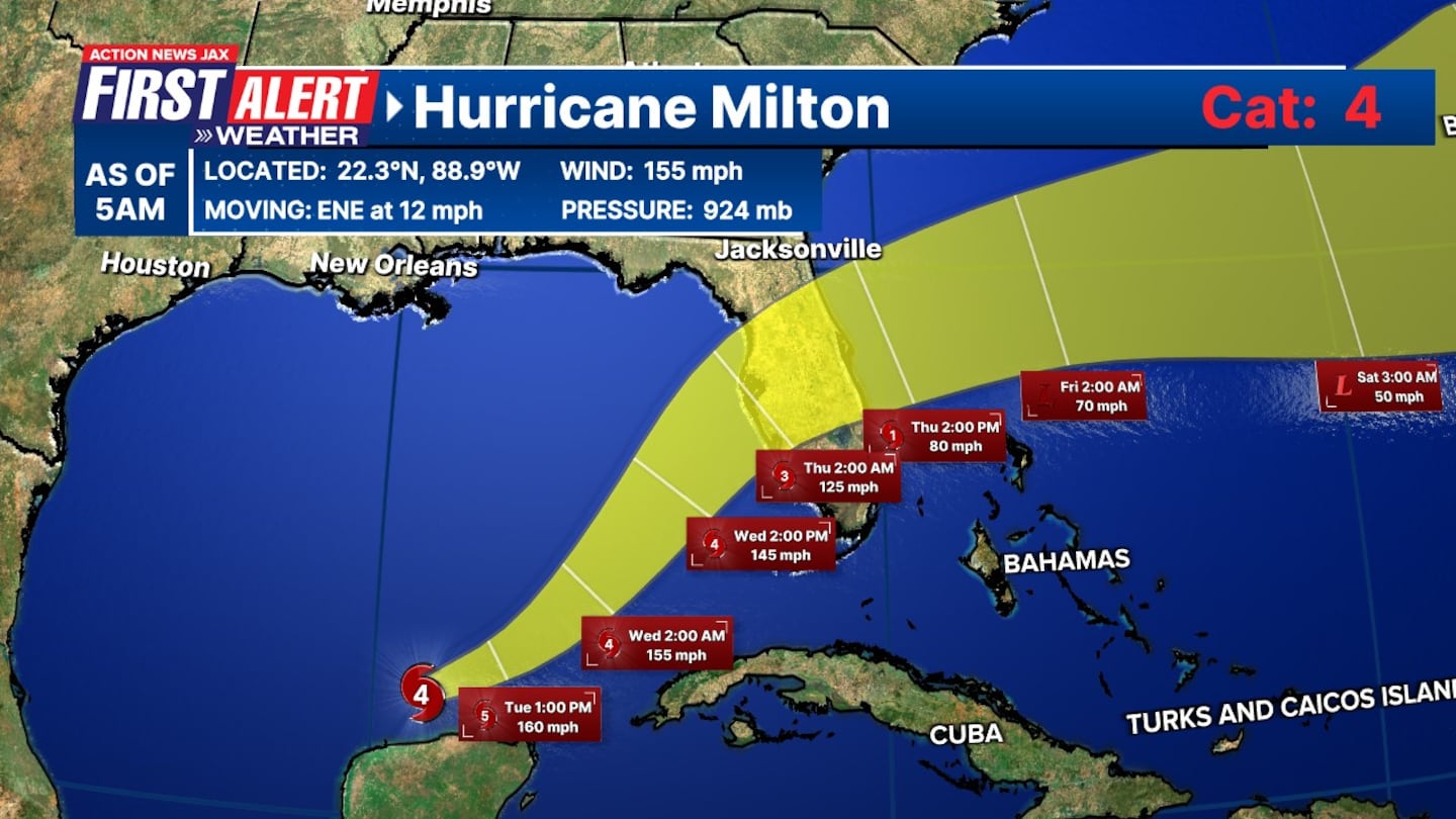
Update, 10/8/24, 4:19 a.m.: The latest update has Milton as a Category 4 Hurricane on Tuesday morning in the Southern Gulf of Mexico.
Action News Jax First Alert Weather Team expects local impacts from the storm to arrive Wednesday afternoon and linger into Thursday.
Here’s a link to more local impact details on Milton in "Talking the Tropics with Mike."
Update, 10/7/24, 5:30 p.m.: As of the latest update, Milton’s winds have increased to 180 mph.
Update, 10/7/24, 5 p.m.: Putnam County is recommending evacuation for those who live in Zones F and A. Anyone who has questions is asked to call the Citizen Information Center at 386-329-1094.
Update, 10/7/24, 2 p.m.: Milton’s winds are up to 175 mph.
Update, 10/7/24, noon: Milton has rapidly intensified into a major Category 5 Hurricane with estimated maximum sustained winds of 160 mph over the southern Gulf of Mexico. This marks the fourth upgrade of Milton since midnight.
TRACKING THE TROPICS | The latest stats and track. More: https://t.co/W3ACmPc5wI. #FirstAlertWX pic.twitter.com/5BpBSfH9p8
— Garrett Bedenbaugh (@wxgarrett) October 7, 2024
Update, 10/7/24, 9:30 a.m.: Florida Governor Ron DeSantis holds a press conference in Tallahassee on preparation ahead of Hurricane Milton.
Update, 10/7/24, 9:10 a.m.: Milton has rapidly intensified into a major Category 4 Hurricane with estimated maximum sustained winds of 150 mph over the southern Gulf of Mexico. This marks the third upgrade of Milton since midnight.
Hurricane and Storm Surge Watches have been issued for parts of Florida, and a surge of up to 12 feet could impact the Tampa Bay region. Preparations need to be made. Keep listening to the First Alert Weather team and local officials.
A flood warning has been issued for the entirety of our viewing coverage area ahead of Hurricane Milton.
More local impact details on Milton in “Talking the Tropics with Mike.”
8:05 AM CDT Monday Update: Milton rapidly intensifies into a category 4 hurricane. The maximum sustained winds have now increased to 150 mph (240 km/h) and the minimum pressure has fallen to 940 mb. pic.twitter.com/wlJXbB5lkr
— National Hurricane Center (@NHC_Atlantic) October 7, 2024
A Flood Watch has been issued for nearly our entire viewing area in advance of Hurricane #Milton. @ActionNewsJax #firstalertwx #flwx #gawx pic.twitter.com/WtNewAGNfk
— Trevor Gibbs (@TrevorsWeather) October 7, 2024
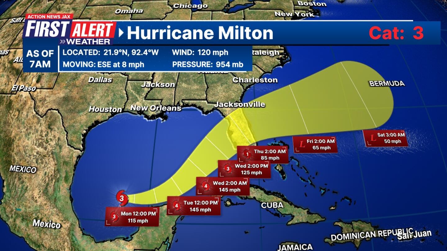
Update, 10/7/24, 6:00 a.m.: The National Hurricane Center has upgraded Milton to a Category 3 “major” hurricane, with maximum sustained winds increased to 120 mph. This marks the second upgrade of Milton since midnight.
More local impact details on Milton in “Talking the Tropics with Mike.”
6:00 AM CDT Monday Update: NOAA Hurricane Hunters find #Milton a major hurricane. The maximum sustained winds have increased to 120 mph (195 km/h). #Milton is now a category 3 hurricane on the Saffir-Simpson Hurricane Wind Scale. https://t.co/tW4KeGe9uJ pic.twitter.com/EYkFxvTozk
— National Hurricane Center (@NHC_Atlantic) October 7, 2024
TRACKING THE TROPICS | The latest stats and track. More: https://t.co/W3ACmPc5wI. #FirstAlertWX pic.twitter.com/Ou1PQnmMh7
— Garrett Bedenbaugh (@wxgarrett) October 7, 2024
Original Story: Hurricane Milton is gaining strength over the southern Gulf of Mexico, with maximum sustained winds of 100 mph (155 km/h). Storm Surge and Hurricane Watches have been issued for portions of Florida, with the storm expected to impact the west coast by midweek.
Follow Action News Jax Meteorologists on Twitter for updates:
Mike Buresh | Garrett Bedenbaugh | Corey Simma | Trevor Gibbs
Watches and Warnings Issued
- Hurricane Warning: Coast of the Yucatan Peninsula of Mexico from Celestun to Rio Lagartos
- Hurricane Watch: Coast of the Yucatan Peninsula from Rio Lagartos to Cabo CatocheFlorida Gulf coast from Chokoloskee to the Suwannee River mouth, including Tampa Bay and the Dry Tortugas
- Storm Surge Watch: Florida Gulf coast from Flamingo northward to the Suwannee River, including Charlotte Harbor and Tampa Bay
- Tropical Storm Warning: Coast of the Yucatan Peninsula from Rio Lagartos to Cancun
- Tropical Storm Watch: Florida Gulf coast from Flamingo to south of ChokoloskeeFlorida Gulf coast north of the Suwannee River mouth to Indian PassLower, Middle, and Upper Florida Keys, including Florida Bay
Hurricane Milton - Latest Projections
Hurricane Milton is moving east-southeast and is expected to turn east and northeast by Tuesday and Wednesday. On its current path, Milton will approach the west coast of Florida by Wednesday. The storm is forecast to intensify into a major hurricane later today.
More local impact details on Milton in “Talking the Tropics with Mike.”
Read: Gov. DeSantis warns Floridians to prepare for ‘a lot of power outages’ ahead of Hurricane Milton
Hazards Affecting Land
- Storm Surge: A life-threatening storm surge is expected along the Florida Gulf coast, especially from Anclote River to Englewood and in Tampa Bay. Water levels could rise 8-12 feet in these areas if peak surge coincides with high tide. Dangerous and destructive waves will accompany the surge.
- Expected surge heights:
- Anclote River to Englewood: 8-12 ft
- Tampa Bay: 8-12 ft
- Yankeetown to Anclote River: 5-10 ft
- Englewood to Bonita Beach: 5-10 ft
- Charlotte Harbor: 5-10 ft
- Bonita Beach to Chokoloskee: 4-7 ft
- Suwannee River to Yankeetown: 3-5 ft
- Rainfall: Heavy rain will accompany Milton, with 5-10 inches expected across portions of the Florida Peninsula and the Keys through Wednesday. Localized totals could reach 15 inches, bringing the risk of flash, urban, and river flooding.
- Rainfall totals:
- Florida Peninsula & Keys: 5-10 inches, up to 15 inches in isolated areas
- Northern Yucatan Peninsula: 2-4 inches
- Winds: Hurricane conditions are expected in the Yucatan Peninsula today and could reach parts of the Florida Gulf coast by Wednesday. Tropical storm-force winds will extend outward up to 80 miles (130 km) from the center, with hurricane-force winds extending up to 25 miles (35 km).
- Surf: Swells generated by Milton will affect the Gulf Coast, causing dangerous surf and rip current conditions. Coastal residents and beachgoers are urged to stay vigilant.
Preparations
Residents along the Florida Gulf Coast should complete their storm preparations as soon as possible. Pay attention to local evacuation orders, especially in areas under Hurricane or Storm Surge Watches. Conditions are expected to deteriorate by Wednesday as Milton nears Florida.
Stay tuned for updates as Milton continues to strengthen, and further watches and warnings may be issued later today.
>>> STREAM ACTION NEWS JAX LIVE <<<
[DOWNLOAD: Free Action News Jax app for alerts as news breaks]
Read: Hurricane Milton: Local closings, cancellations, resources
[SIGN UP: Action News Jax Daily Headlines Newsletter]
Click here to download the free Action News Jax news and weather apps, click here to download the Action News Jax Now app for your smart TV and click here to stream Action News Jax live.


